Part 93 "Flight Restrictions" Airspace Area: Graphics
FAA Chart

Aerial Diagram
Aerial Diagram: Operating Detail Above 3,500 feet
Pilot Courses of Instruction
Airspace & Related Information
Steve Sconfienza, Ph.D.
Airline Transport Pilot
Flight Instructor: Airplane Single and Multiengine; Instrument Airplane
cell: 518.366.3957
e-mail: docsteve@localnet.com
| Class | Visibility & Cloud Clearances | Base & Upper Boundary | IFR Clearance Required? | Communications Required | |
|---|---|---|---|---|---|
(for Q codes see Aviation Q Codes) |
|||||
Notes & References to the Airspace Table:Reference: 14 CFR 91.126, et. seq., 91.155. |
|||||
|
Notes: |
|||||
| * | Airspace definitions are for the continental United States and adjacent waters: airspace over Hawaii and the Alaskan peninsula west of 160 degrees W. longitude have certain variations. | ||||
| ** | All IFR (i.e., any flight in weather less than that prescribed for VFR, even when not operating in IMC) requires aircraft and pilot qualifications as specified for IFR regardless of requirement for flight plan or clearance. | ||||
| *** | Class E airspace over Class A is a somewhat elusive definition, but it is defined in the AIM ( in Chap. 3, Sect. 2, Para. 6(e)(7)) as ". . . that airspace above FL 600[.]"). | ||||
| G | < 1200 ft. QFE | >= 1200 ft. QFE | |||
day
|
day
|
Base:
Upper Boundary:
|
NO | For an airport with an operating control tower, communications must be established prior to 4 nautical miles from the airport, up to and including 2,500 feet AGL (no specific clearance required to enter four-mile ring) | |
night
|
night
|
||||
|
>= 10,000 ft. QNH (>= 1,200 ft. QFE) day/night
|
|||||
| E | < 10,000 ft. QFE | >= 10,000 ft. QFE | |||
|
|
Base:
Upper Boundary:
|
YES | For an airport with an operating control tower, communications must be established prior to 4 nautical miles from the airport, up to and including 2,500 feet AGL (no specific clearance required to enter four-mile ring) | |
| C/D/E | Surface Area | Aloft | |||
or
|
|
Base:
Upper Boundary:
|
YES |
|
|
| B | Surface Area | Aloft | |||
or
|
|
Base:
Upper Boundary:
|
YES | Clearance required to enter (& maintain radio communications) | |
| A | All operations | ||||
|
Base:
Upper Boundary:
|
YES | Clearance required to enter (& maintain radio communications) | ||
| F |
Class F generally:Class F is generally classified as a type of uncontrolled airspace, like Class G. In Class F airspace, operations may be conducted under IFR or VFR. However, unlike Class G, ATC will provide separation to aircraft operating under IFR, but only so far as practical, and ATC may only provide advisory services. Class F airspace of this nature has been designated in Austria, Germany, Hungary, and the U.K. (see Eurocontrol Airspace Classification).Class F in North America:Class F may also be used to designate certain special use airspace: this would be areas reserved for non-standard flight operations or other restrictions. Class F airspace of this nature has been designated in Canada (and is recognized as such by the U.S. FAA): Advisory (A) allows general use with specified limitations; Restricted (R) only allows aircraft approved by the controlling agency responsible for the airspace; Danger (D) designates such areas over international waters. Examples of this airspace are aerobatic (A), flight test (F), hang gliding (H), military (M), parachute jumping (P), soaring (S), and training (T) areas.Class F in The United States:Class F has never been designated in the United States. |
||||
Note:
Special Airspace: DC SFRA: See below.
Reference:
14 CFR 91.215.
| Area | Speed (indicated airspeed) | |
|---|---|---|
|
Reference: 14 CFR 91.117; |
||
| < 10,000 ft. QNH | 250 knots | |
When:
or
or
|
200 knots | |
Holds:
|
200 knots 230 knots 265 knots |
} } 1 minute inbound leg : 1 1/2 minute inbound leg |
|
Note: Special Airspace: NY SFRA/Hudson Riverr Corridor: See below. DC SFRA: See below. |
||
| Altitude | Requirement | |
|---|---|---|
| > 12,500 ft. QNE | Required flight crewmembers | Flight at those altitudes that is over 30 minutes |
| > 14,000 ft. QNE | Entire flight at those altitudes | |
| > 15,000 ft. QNE | All occupants | |
Note:
Pressure altitudes, not MSL.
Reference:
14 CFR 91.211, et. seq.
These parts are covered in 14 CFR 121.327, et. seq. and 14 CFR 135.89 & 135.157.
(Excel workbook with two worksheets [navigate with tabs at bottom])
Pursuant to 14 CFR Section 99.7, special security instructions, commencing one hour before the scheduled time of the event until one hour after the end of the event, all aircraft and parachute operations are prohibited at and below 3,000 ft. feet agl within a three nautical mile radius of any stadium having a seating capacity of 30,000 or more people in which a major league baseball, National Football League, NCAA Division One Football, or major motor speedway event is occurring.
(See the N.Y. Yankees game schedule, and don't forget the Pinstripe Bowl).
Let's all hope that this TFR is very active through the month of October, while there are no TFRs over Fenway Park.
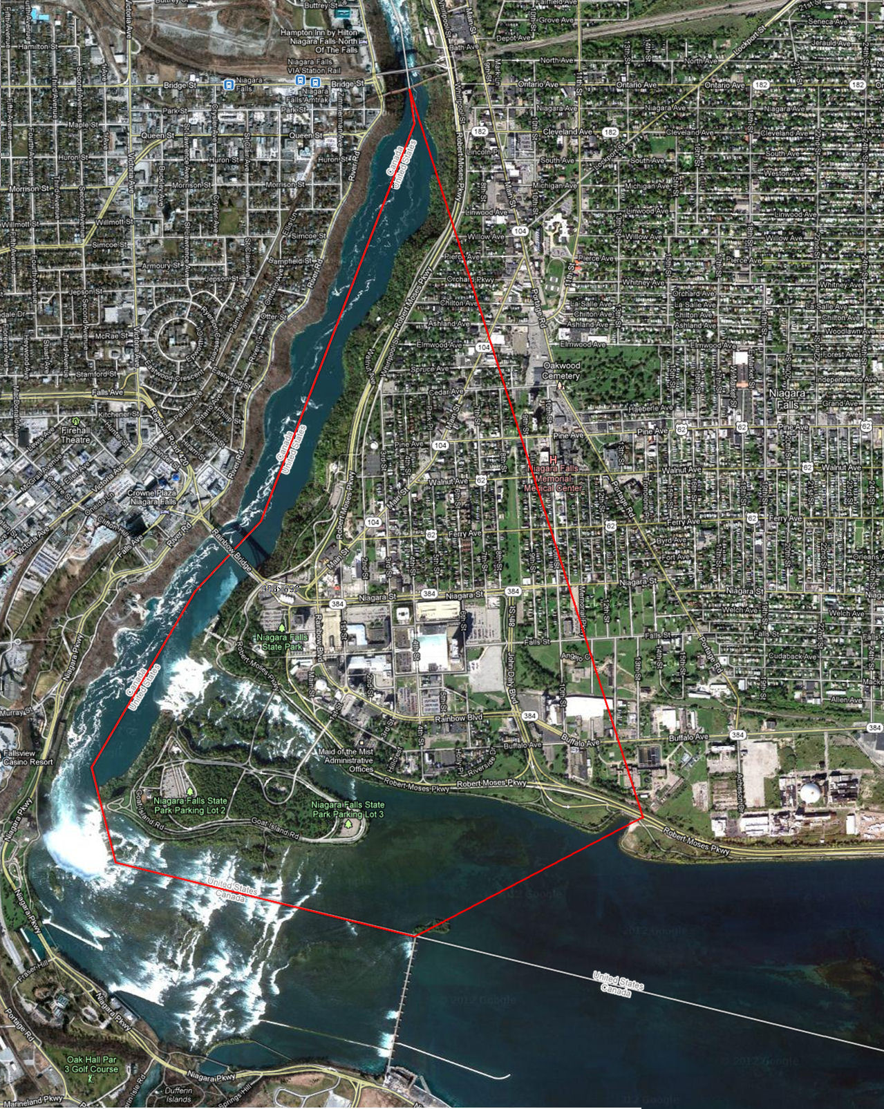
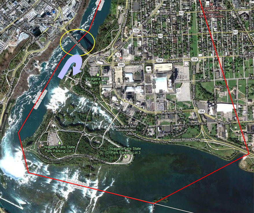
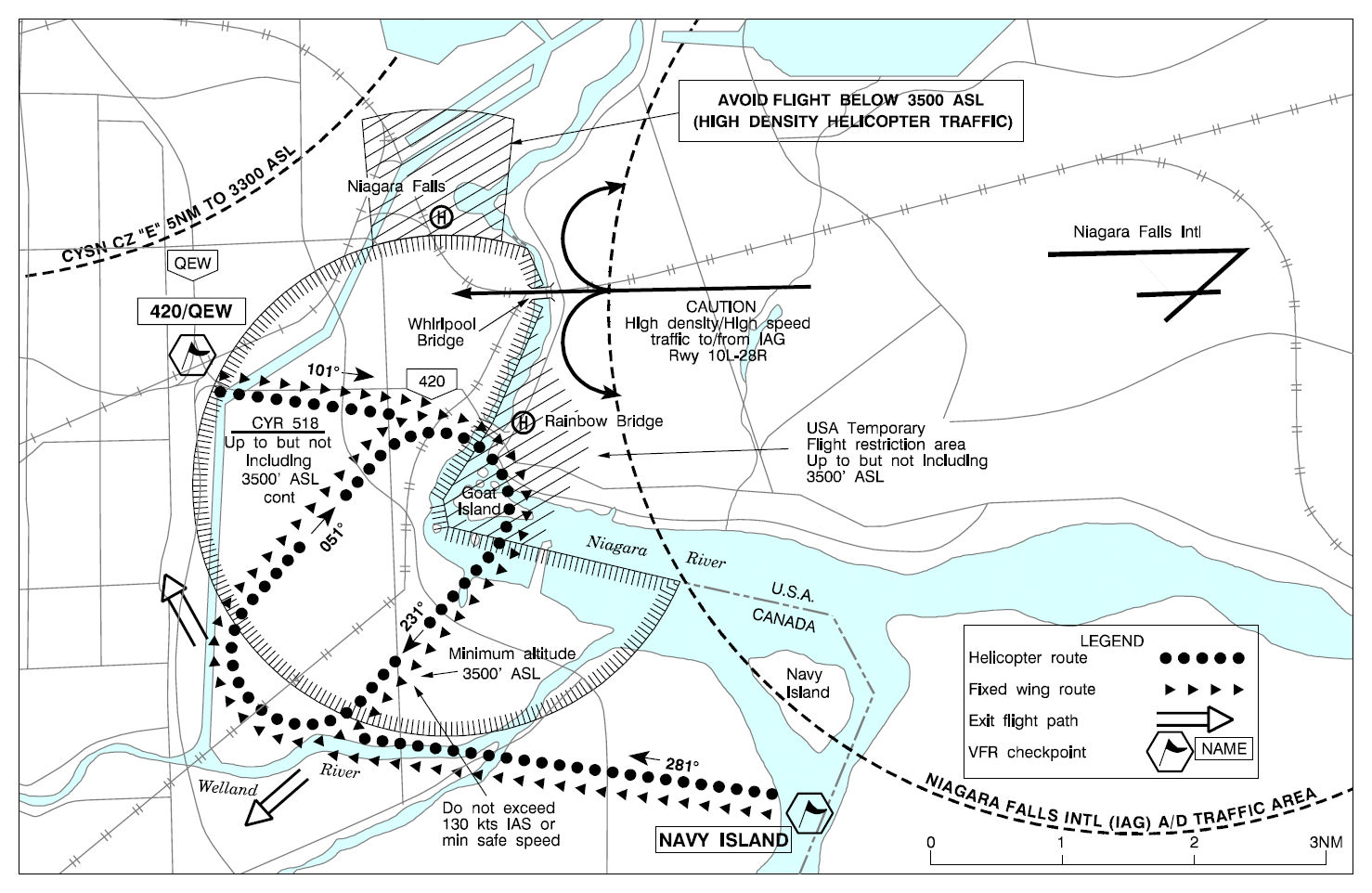
Flight restrictions exist in the area around Niagara Falls. There are two areas: one that amount to a non-flying zone (below 3,500 feet) and one that has specific flight operations procedures. There are two areas: one that amount to a non-flying zone (below 3,500 feet) and one that has specific flight operations procedures. . These areas are not exactly defined as a Special Flight Rules Area (SFRA) but are essentially the same, and -- with few exceptions -- all flights below 3,500 feet in the Flight Restrictions prohibited except for those made under an MOU with the Transport Canada.
The restricted airspace is defined as within a line from
Generally, no flight is permitted below 3,500 feet MSL.
The minimum altitude for VFR flight over the Scenic Falls area is 3,500 feet MSL. The following procedures are mandatory for flights over the area:
Also be aware of the following:
One noteworthy point is that Part 93 does not describe the ceiling of the "Flight Restrictions Area" whose base is 3,500 feet. Clearly, transient flights at 10,000 feet should not have a limitation on them; however, is five thousand above the circuit? One might assume that most traffic would be right at 3,500, maybe up to 4,000, so then what? So what is the minimum altitude for VFR flight that simply crosses through this airspace? Goat Island is at about 550 feet, while both cities (U.S. & Canada) are between 550 and 650 feet; therefore, the lowest altitude at whcih the hemispheric rule applies is 4,500 feet; so, one might guess 4,500 on westerly headings and 5,500 on easterly headings, but be careful at 4,500.
References:
14 CFR 93, Subpart E, "Flight Restrictions in the Vicinity of Niagara Falls, New York," 93.71, et. seq..
Airport/Facility Directory: Special Notices (retrieved from "NE, 20 SEP 2012 to 15 NOV 2012" edition, page 373).
Transport Canada has instituted similar restrictions in Canadian airspace with a restricted area, CYR518, which similarly exists below 3,500 feet.
The only operations permitted below 3,500 feet in either the U.S. Part 93 Restricted Area or in Canadian Restricted Airspace CYR518 are sightseeing aircraft operating on the Canadian side of the river under an MOU with Transport Canada.
Canadian airspace operations above CYR518
Reference:
Canada Flight Supplement, Niagara Falls VFR Terminal Procedures Chart
| From the outermost area to the innermost area and the Class B and Class D airspaces | |
|---|---|
References & Additional Material: |
|
Code of Federal Regulations |
|
|
14 CFR 91.117; 14 CFR 91.161; 14 CFR 93, Subpart V (93.331, et. seq.). |
|
NOTAMs |
|
|
NOTAM 0/8326 (General 60-mile ring, DC SFRA, and DC FRZ operations); NOTAM 1/1155 (Speed limits within 60- and 30-mile rings); NOTAM 1/6386 (Leesburg Maneuvering Area). |
|
Additional MaterialSee the DC SFRA "Cheat Sheet" (PDF)See the Pilots' Briefcase for downloadable graphics of the SFRA |
|
| 60 Mile Ring: | |
|
|
| DC SFRA: | |
|
|
| Flight Restricted Zone (FRZ): | |
|
|
| Washington Tri-Area Class B | |
|
|
| Class D Airspace within the 60-mile ring | |
|
|
Automatic dependent surveillance: broadcast (ADS-B) is a surveillance technology in which an aircraft determines its position via satellite navigation and periodically broadcasts it, enabling it to be tracked. The information can be received by air traffic control ground stations as a replacement for secondary surveillance radar, as no interrogation signal is needed from the ground. It can also be received by other aircraft to provide situational awareness and allow self-separation. This is basically an airborne collision avoidance system
ADS-B is
The requirement for ADS-B "out" became effective on 1 January 2020 (that is, an ADS-B system that transmits data); there is no requirement for ADS-B "in" (that is, an ADS-B system that receives data). The FAA airspace requirements intentionally exclude some airspace that is frequently used by general aviation.
| Airspace | Altitude | System Type |
|---|---|---|
| A | All aircraft equipped at all altitudes withing Class A airspace | 1090ES |
| B | All aircraft equipped
|
1090ES or UAT |
| C | All aircraft equipped
|
1090ES or UAT |
| D | No requirement | N/A |
| E | All aircraft equipped
|
1090ES or UAT |
| G | No requirement | N/A |
[ TOP ]
[ FLYING HOME ]
|

rev. 4 February 2020
Copyright © 2012 - 2020
Steve Sconfienza, Ph.D.
All Rights Reserved