Instrument Pilot Course of Instruction
Steve Sconfienza, Ph.D.
Airline Transport Pilot
Flight Instructor: Airplane Single and Multiengine; Instrument Airplane
cell: 518.366.3957
e-mail: docsteve@localnet.com
Instrument Approach Briefing
The point of "briefing" an instrument approach is to insure that you, the flight crew, anyone involved in the approach,
know what to do before things are happening too quickly to respond in a competent manner.
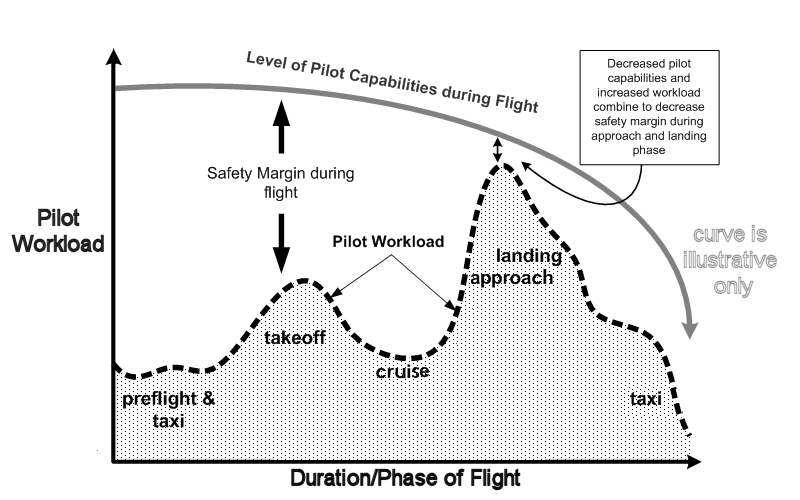
Pilots' workload is highest during the approach and landing phase of a flight,
and this is when workload- or stress-related errors are most likely.
The briefing is not meant to be a complete review of all instruemtn procedures and flight rules
(you are supposed to know that and be practicing it already), just a familiarization exercise with respect to the approach to be flown.
First, take care of the paperwork. Ensure you're using correct and current chart.
Pay attention to the header section of the approach charts: you may find multiple cities with the same name but in different states
(e.g., Logan in Alabama and Logan in Massachusetts), and you may find multiple airports under the same city name
(e.g., Chicago Midway and Chicago O'Hare), sometimes with the same runways and approaches
(e.g., Chicago Midway, ILS to 4R, and Chicago O'Hare, ILS 4R ).
Second, familiarize yourself with the environment. Review the general navaid and airport information
(on NOS charts this reads directly across the top).
Finally, insure you know how to fly the apporach. Don't freelance this step going down final.
Review the final approach fix information, minimum altitudes, and the missed approach point & procedure.
- Approach ID:
- City and State Name
- Airport Name
- Approach ID (Approach Type to Runway, Approach Type and Letter ID to Runway, or Approach Type and Letter ID)
- Chart Expiration Date
- e.g.,
- "Chicago, Illinois; Midway; ILS 4 right; 23 August 2012"
- Approach Environmnt:
- Navaid Frequency
- Approach Course
- Runway Landing Length
- Touchdown Zone Elevation
- Airport Elevation
- e.g.,
- "Localizer I-H-K-H, 111.5, 044 degrees; runway 5928 feet, touchdown zone 619 feet, airport 620 feet"
- Final Approach Fix and Altitude
- ID Navaid or fix
- FAF Crossing Altitude
- or Procedure Turn altitude if no FAF
- or Glide Slope Interctpt altitude if ILS
- e.g.,
- "Final Approch Fix: Intercept at 2500 or Locater/Outer Marker at 2500"
- Lowest altitudes:
- DH and/or MDA
- both QNH & QFE
- insure the proper aircraft category: A/B/C/D/E
- Category A: 1.3 VSO less than 91 knots.
- Category B: 1.3 VSO 91 knots or more but less than 121 knots.
- Category C: 1.3 VSO 121 knots or more but less than 141 knots.
- Category D: 1.3 VSO 141 knots or more but less than 166 knots.
- Category E: 1.3 VSO 166 knots or more.
- e.g.,
- "Category A, Decision Height: 869, 250 feet AGL; Localizer only: MDA 1120, 501 feet AGL"
- Missed Approach Point:
- DH, Time from FAF, Navaid, or Fix
- e.g.,
- "Missed approach: at Decision Height; Localizer only, at 90 knots ground speed, 3:24 past the marker"
- Missed Approach Procedure
- As charted: expect MAP instrctions from ATC and follow those.
- e.g.,
- "Missed Approach Procedure: climb straight ahead to 1100 feet, climing right turn to 2100 feet/intercept EON 001 degree radial to IGECY/EON 20 mile DME, climb to 2600 feet to EON, hold north-west on the 001 radial, right turns."
Once the above is taken care of, start setting-up the airplane.
- Altimeter should already be set from ATC or ATIS
- For Localizer/ILS, VOR, and NDB approaches,
- Nav Aids:
- Tune-in and identify
- No flags
- Ground speed should be estimated for timed-MAP approaches
- Current surface wind velocity from ATC or ATIS
- Winds aloft (i.e., FAF to surface) from pre-flight AWC and in-flight estimates
- For GPS approaches,
- RAIM:
- Perform check as appropriate for GPS unit prior to IAF.
- Minima:
- LPV: Localizer Performance with Vertical guidance
- LNAV/VNAV: lateral navigation with advisory descent guidance
- LNAV: lateral navigation only, no descent guidance
- CIRCLING: when straight-in minima are not published or circling is desired.
Also, make note of the following:
- Approach Courses and intermediate altitudes
- STARs/Route segments from feeder facilities
- IAF to intermediate fixes to FAF
- Be congnizant of special requirements and inoperative components
- Radar or DME required?
- Absence of local altimeter setting?
- Increased MDA/DH with components (e.g., approach lights) inoperative?
Call for the standard pre-landing checklist.
Download Instrument Briefing Checklist in PDF format
 |
|

rev.
9 August 2012
Copyright © 2012-2020
Steve Sconfienza, Ph.D.
All Rights Reserved

